Japan Earthquake: Deep M6.1 Quake Off Mie Felt in Fukushima, No Tsunami
By Eoin Villarin, 2026-11-02
A deep magnitude 6.1 earthquake struck off Mie Prefecture on November 1, 2026. Why it shook Fukushima harder than Mie, what else 2026 brought, and how to stay safe.
What happened in the latest Japan earthquake on November 1, 2026?
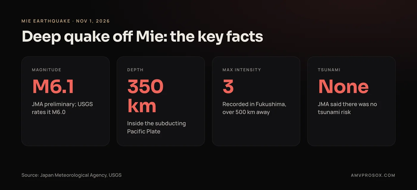
A preliminary magnitude 6.1 earthquake (USGS: M6.0) struck about 350 km beneath the sea off southeast Mie Prefecture at about 7:15 a.m. JST on November 1, 2026. Because it occurred deep inside the Pacific Plate, the strongest shaking, intensity 3 on Japan's scale, was recorded in Fukushima Prefecture rather than near the epicenter. JMA said there was no tsunami risk, and there were no immediate reports of major damage or casualties.
Key takeaways
- A preliminary magnitude 6.1 earthquake (USGS: M6.0) struck about 350 km deep off southeast Mie Prefecture at about 7:15 a.m. JST on November 1, 2026.
- JMA said the quake posed no tsunami risk, and there were no immediate reports of major damage or casualties.
- The strongest shaking, intensity 3, was recorded in Okuma, Futaba and Namie in Fukushima Prefecture, more than 500 km away, while no point in Mie registered shaking.
- JMA attributes the distant shaking to the quake occurring inside the subducting Pacific Plate, an effect known as an abnormal seismic zone.
- Japan's deadliest quake of 2026 was the M7.1 Kumamoto earthquake on July 28, which reached intensity 7 and killed 38 people according to Kumamoto Prefecture.
- At M6.1, the November 1 quake was below the M6.8 threshold that starts a Nankai Trough megaquake assessment.
A deep earthquake shook Japan early on Sunday, November 1, 2026. It struck off the southeast coast of Mie Prefecture at about 7:15 a.m. local time, with a preliminary magnitude of 6.1, about 350 km below the seabed. The Japan Meteorological Agency (JMA) said it posed no tsunami risk, and there were no immediate reports of major damage or casualties.
The unusual part was where people felt it. The strongest shaking, intensity 3 on Japan's scale, was recorded in Fukushima Prefecture, more than 500 km to the northeast. JMA's report did not list a single observation point in Mie itself. Tokyo and much of eastern Japan felt a gentle sway at intensity 2.
If you live in Japan, plan to visit, or work with people there, it is worth knowing how Japan reports quakes and where reliable alerts come from.
The facts here come from JMA's official earthquake report, the US Geological Survey (USGS), Japan's Earthquake Research Committee, and reporting by Kyodo, Xinhua and NBC News, all linked inline.
Japan earthquake on November 1, 2026: at a glance
| Detail | What was reported |
|---|---|
| Time | About 7:15 a.m. JST, Sunday, November 1, 2026 (22:15 UTC on October 31) |
| Location | Off the southeast coast of Mie Prefecture, about 58 km south-southeast of Shima |
| Magnitude | M6.1 (JMA, preliminary); M6.0 (USGS) |
| Depth | About 350 km (JMA); 352 km (USGS) |
| Strongest shaking | Intensity 3 in Okuma, Futaba and Namie, Fukushima Prefecture |
| Tsunami | None. No tsunami warning was issued |
| Damage | No immediate reports of major damage or casualties |
What happened in the Mie earthquake?
JMA's earthquake and seismic intensity report, issued at 7:22 a.m., placed the hypocenter at 33.7 degrees north, 137.1 degrees east, about 350 km deep, with a preliminary magnitude of 6.1. Its English comment was short: "This earthquake poses no tsunami risk."
The USGS event page lists it as a moment magnitude 6.0 at a depth of 352 km, 58 km south-southeast of the coastal city of Shima. Xinhua carried the same JMA figures and confirmed no tsunami warning was issued.
Intensity 3 was measured at three observation points, in the towns of Okuma, Futaba and Namie on Fukushima's Pacific coast. Intensity 2 was recorded across Miyagi, Ibaraki, Tochigi, Gunma, Saitama, Chiba, Kanagawa, Tokyo's 23 wards and parts of Hokkaido. In total, JMA logged shaking of intensity 1 or more in 23 prefectures, from Hokkaido to Okayama and Tokushima.
Dimsum Daily reported no immediate reports of major damage or casualties. The USGS automated PAGER estimate was green, which on the USGS alert scale means an estimated zero fatalities and under $1 million in losses.
JMA's list of felt earthquakes showed no further felt quakes off Mie through late morning on November 2, and nothing larger anywhere in Japan in that window.
Why was an earthquake off Mie felt most in Fukushima?
JMA's explanation, as reported by Kyodo, is that the quake happened inside the Pacific Plate, the slab of ocean floor that sinks beneath Japan from the east. Seismic waves travel through that slab with little loss of energy, so shaking was carried toward Fukushima, Tohoku and Kanto while areas near the epicenter barely registered it.
Japanese seismologists call this an abnormal seismic zone (ijo shin'iki). Weathernews described it as typical of deep earthquakes, which are relatively infrequent, and stressed that the seismic activity itself is not abnormal.
It has happened this way before. In November 2003, a magnitude 6.5 quake about 400 km beneath the sea off the southeast Kii Peninsula produced intensity 4 in Namie, Fukushima, as well as in Hitachi and Utsunomiya, according to Japan's NIED Hi-net. NIED noted that the Pacific coast from Kanto northward shook harder than the Kinki region next to the epicenter.
Depth also kept the shaking gentle. At 350 km down, the energy travels a very long path before it reaches anyone, so even the hardest-hit spots only rattled dishes.
How does Japan measure earthquakes? Magnitude vs shindo
Japan reports two different numbers, and headlines often mix them up.
- Magnitude is the size of the earthquake at its source, one number per quake. JMA and the USGS calculate it differently, so their figures can differ by a few tenths.
- Seismic intensity (shindo) is how hard the ground shakes at a specific place. It depends on distance from the source and local ground conditions, and JMA measures it with seismic intensity meters.
The JMA intensity scale has 10 levels: 0, 1, 2, 3, 4, 5 Lower, 5 Upper, 6 Lower, 6 Upper and 7, which is why you may see it called a 0 to 7 scale. Here is what a few levels feel like, based on JMA's intensity tables:
| Intensity | What people typically notice |
|---|---|
| 2 | Many people resting indoors notice it; hanging lamps may sway slightly |
| 3 | Most people indoors feel it, many sleepers wake, and dishes may rattle |
| 5 Lower | Many people are frightened; dishes and books may fall and loose furniture may shift |
| 6 Upper | Standing is impossible and most unsecured furniture moves or topples |
| 7 | The top of the scale; unsecured furniture topples or may be thrown |
On November 1, the maximum was 3: a noticeable jolt, not a damaging one.
What other major earthquakes hit Japan in 2026?
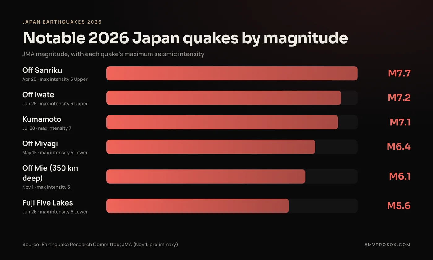
Japan's government Earthquake Research Committee has published evaluations for several events. The notable ones, using the committee's magnitudes:
- April 20, off Sanriku (M7.7): The largest of the year, with maximum intensity 5 Upper in Aomori and a 79 cm tsunami at Kuji Port, Iwate, per the committee's evaluation. The USGS rates it M7.4. NBC News reported tsunami warnings for Iwate, Aomori and Hokkaido, and an advisory about a slightly higher risk of a larger quake in northern Japan.
- May 15, off Miyagi (M6.4): Maximum intensity 5 Lower in Miyagi, per the May review.
- June 25, off Iwate (M7.2): Maximum intensity 6 Upper in Aomori and a 0.1 m tsunami at Kuji Port. The committee says it caused damage and injuries. The USGS rates it M6.9.
- June 26, eastern Yamanashi and Fuji Five Lakes (M5.6): Smaller but shallow, about 20 km deep, it still reached intensity 6 Lower and caused damage and injuries.
- July 28, Kumamoto (M7.1): The deadliest of the year. It reached intensity 7 at a depth of about 15 km on the Hinagu Fault Zone, per the committee, and NBC News reported about 300,000 people were told to seek shelter. Kumamoto Prefecture put the death toll at 38 after an August 20 revision. The USGS rates it M6.8.
The Yamanashi and Mie quakes make a useful pair. The shallow M5.6 reached intensity 6 Lower, while the deep M6.1 reached only 3. Magnitude alone does not tell you how hard the ground will shake.
Does this raise the risk of a Nankai Trough megaquake?
The Nankai Trough is the offshore subduction zone where Japan's government expects a future magnitude 8 to 9 earthquake.
In September 2025, the Earthquake Research Committee revised the 30-year probability of such a quake to about 60 to 90 percent or higher using one method, and 20 to 50 percent using another, according to Japan Science and Technology Agency and Jiji Press. The committee said it could not determine which method was scientifically superior, and its chair said no one can say clearly when it will happen.
Japan also issues short-term alerts. As Hamamatsu City explains, a magnitude 6.8 or larger quake in the Nankai Trough area triggers a JMA investigation. A magnitude 8 or larger event leads to a megaquake warning, and magnitude 7 to just under 8 leads to a megaquake advisory.
The first advisory came on August 8, 2024, after a magnitude 7.1 quake off Miyazaki, and the call for extra precautions ended on August 15, according to Nippon.com. As NBC News explained at the time, an advisory signals higher than usual risk, not a prediction.
The November 1 quake, at M6.1, was below the M6.8 level that starts a Nankai Trough assessment, and its source was deep inside the Pacific Plate. I found no Nankai Trough advisory issued for it. The useful takeaway is readiness, not worry: the government's 2025 damage estimate, summarized by Nippon.com, found that fast early evacuation could cut projected tsunami deaths by more than half.
What should residents and travelers in Japan do?
Alerts only help if your phone can receive them and you know what to do next. Start with these official tools:
- Safety tips app: The Japan Tourism Agency's Safety tips app, hosted by JNTO, pushes Earthquake Early Warnings, tsunami warnings and weather warnings in 15 languages. Its App Store listing says it is free and warns of quakes of intensity 4 or greater at locations you choose.
- NHK WORLD-JAPAN app: The free NHK WORLD-JAPAN app sends push alerts on earthquakes, tsunamis and weather emergency warnings in 11 languages.
- JMA: JMA's earthquake information pages are the primary source for magnitude, intensity and tsunami status.
- Japan Visitor Hotline: JNTO's hotline at 050-3816-2787 (+81-50-3816-2787 from abroad) runs 24 hours a day in English, Chinese and Korean, including for natural disasters.
JMA says the gap between an early warning and strong shaking is seconds to a few tens of seconds, and places close to the source may not get the warning in time.
When the ground shakes, the Japan Tourism Agency's earthquake flowchart recommends:
- In a hotel: Protect your head and shelter under a sturdy table. Do not rush outside, and follow staff instructions.
- In shops, stations or airports: Protect your head in an open area or near a solid pillar, away from falling objects. Avoid elevators until they are confirmed safe.
- Outdoors in a city: Cover your head with a bag, keep away from buildings, then move to an open space.
- On a train: Hold the handrails, protect your head, and never step down onto the tracks on your own.
- Near the coast or a river: After the shaking, move to higher ground or a tsunami shelter. Waves can arrive repeatedly and travel up rivers, so stay away until warnings are lifted.
If you live in Japan, Hamamatsu City's guidance makes a good weekend checklist: check your emergency kit, confirm contact and evacuation plans with family, move items down from high places, and keep a clear path to your front door.
Frequently asked questions
Was there a tsunami after the Japan earthquake on November 1, 2026?
No. JMA said the earthquake posed no tsunami risk, and no tsunami warning was issued. Its source was about 350 km deep.
Why was the Mie earthquake felt in Fukushima and Tokyo?
It occurred inside the subducting Pacific Plate, which carries seismic waves efficiently over long distances, an effect known as an abnormal seismic zone. JMA recorded intensity 3 in Fukushima and 2 in Tokyo's 23 wards.
Is it safe to travel to Japan after this earthquake?
The November 1 quake caused no reported major damage and no tsunami. Earthquakes are part of life in Japan, so install the Safety tips or NHK WORLD-JAPAN app and check JMA and your own government's travel advice before you go. Those official sources are the right guide for your situation.
What is the difference between magnitude and shindo?
Magnitude is the size of the earthquake at its source, with one value per quake. Shindo is JMA's 10-level intensity scale, from 0 to 7, describing how strongly the ground shakes at each location. A deep quake can have a fairly large magnitude but low shindo everywhere.
Did the November 1 earthquake trigger a Nankai Trough megaquake advisory?
No advisory was issued that I could find. At M6.1, it was below the M6.8 threshold that starts a Nankai Trough assessment, and it originated deep inside the Pacific Plate. The first Nankai advisory was issued in August 2024 and lifted a week later.
What was the strongest earthquake in Japan in 2026?
By magnitude, it was the April 20 quake off Sanriku, rated M7.7 by Japan's Earthquake Research Committee and M7.4 by the USGS. The most damaging was the M7.1 Kumamoto earthquake on July 28, which reached intensity 7 and killed 38 people according to Kumamoto Prefecture.
The bottom line
The November 1 earthquake off Mie was a magnitude 6.1 event about 350 km deep. It produced no tsunami, no reported major damage, and an unusual shaking pattern that peaked at intensity 3 in Fukushima. It shows how deep quakes behave rather than signaling abnormal activity. In a year that also brought the deadly Kumamoto quake, simple preparation and trusted alert apps remain the best response.
On the business side, if you have customers, staff or partners in Japan, the most useful thing your website can do on days like this is small: a notice banner you can update in a minute, accurate contact details, and pages that load quickly on a phone. If you would like help setting that up on your site or store, you can get in touch with me here.